-
From NASA’s Earth Observatory:
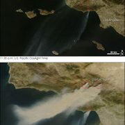
“Driven by Santa Ana winds, several large wildfires flared across Southern California over the weekend of October 20, 2007. This pair of images of the area around Los Angeles on October 21 shows just how rapidly the fires grew. The top image, taken by the Moderate Resolution Imaging Spectroradiometer (MODIS) on NASA’s Terra satellite at 11:35 a.m. local time, shows several active fires (outlined in red) emitting small plumes of smoke. By 2:50 p.m., when the Aqua satellite passed overhead, smoke was pouring from several large blazes northwest of Los Angeles. Although Aqua MODIS only caught the edge of the scene during this satellite overpass, the plumes of smoke and dust that can be seen blowing off the coast in the large image indicate the intensity of the winds and the presence of additional fires farther south.”
To See the satellite images click the “read more” link below
Categories
- Building and Planning
- Carleton's Wind Turbines
- Climate Change
- Conferences
- Cowling Arboretum
- Ecosystem Management
- Emissions and Offsets
- Energy Sources & Uses
- Environmental Justice
- Events
- Food
- Higher Education
- International News
- National News
- News
- STA Program
- Student Life
- Student Projects
- Sustainability
- Sustainable Planning & Development
- Transportation
- Waste